
Pilot
Safety News
A Safety Journal for General Aviation
November, 2005
by Max Trescott,
Master CFI & FAA Aviation Safety Counselor
www.sjflight.com
(650)-224-7124
Index
to Pilot Safety News
Subscribe or Unsubscribe
Welcome!
Once again, it's been a busy month--both for safety related issues to report and
personally. Here are some of the safety related issues discussed in this
issue.
When you have a landing accident, you may want to go around as soon as the idea first crosses your mind or, once on the ground, you may want to stay there if hitting something at slow speed is preferable to taking off again and making things worse. We have the story and photos of a recent taildragger incident at RHV that highlight these issues.
VFR-into-IMC accidents are a big problem in California and we've got the numbers to show that generally less experienced pilots have these types of accidents. Better yet, we have some tools you can use in flight to measure whether you meet the legal inflight visibility and cloud clearance requirements. Unfortunately, our Stupid Pilot Tricks feature is back--you've got to see the video to believe this one.
Out Spotlight this month is on WingX software, which we've been test driving and find helps with many pilot and CFI tasks. Finally, we talk about two recent accidents involving the new Columbia 400 airplane, the fastest piston aircraft available. One was in California and you just have to wonder how this one could have happened.
By the way, I'll be giving a couple of free seminars over the next month or two. On Saturday, November 12, I'll be giving an introduction to the G1000 glass cockpit at 10AM, at the West Valley Flying club in Palo Alto. Cessna, Diamond, and Mooney are currently shipping planes with this glass panel and Beechcraft and Tiger will start to ship in the next few months. We'll spend about 90 minutes talking about how to operate this great cockpit and then we'll have several airplanes open for you to view. If the seminar is crowded, I'll give it again at noon.
Also, on Wednesday, November 16, I'll be giving a Bay Tour Seminar at California Airways at the Hayward airport at 7PM.
Good news--the price of aviation fuel is dropping! I spoke with a local dealer who told me that his next load of AvGas will cost him 31 cents per gallon less. Unfortunately, he still had another two weeks supply of the older, more expensive gas, but at least things are finally headed in the right direction.
Last month, I mentioned that Garmin would soon have the G1000 simulator software on their website. Well, they do now, but it's a little hard to find. Here's the link to the Cessna version. http://shop.garmin.com/accessories_for_product.jsp?sku=010-G1000-C3 From there, you can find the other four versions (Beechcraft, Diamond, Mooney, Tiger) that are also available.
On a personal note, I was busy this month getting my Cirrus Design CSIP designation and am now actively teaching in the SR20 and SR22 glass cockpit aircraft. There's a lot of knowledge to acquire to learn to fly this aircraft, but it's fun to fly and of course speedy. One funny story highlights the need for system knowledge on any aircraft you fly. An instructor told me that one of his clients mentioned that he kept taking fuel samples from a Cirrus but that it continued to have lots of water in it. Turns out he was actually draining Glycol from the TKS anti-icing system! Oops! The drains look the same, but if you fly the SR22, just remember that the fuel drain is the one up front under the engine!
If you have an aviation related website, please consider adding a link to our newsletter website. You'll find all of the past newsletters plus pages devoted to Night Flying and VFR-into-IMC. The website is of course www.pilotsafetynews.com.
Feel free to forward this newsletter to your flying friends and encourage them to subscribe. If you're on the distribution list, you'll receive an email each month highlighting the information contained in the online version of the newsletter. Submissions and feedback are always welcome!
Have fun and fly safely!
best regards,
Max Trescott, Master CFI
650-224-7124
Taildragger
Meets Runway Sign
You haven't
flown until you've flown a taildragger
I often joke while taxiing with clients about avoiding hitting the
many $200 dollar bills sticking up along the edge of the runways and
taxiways. Hard to believe, but that's about what it's costs to
replace one of those blue taxiway or white runway lights if you happen to take
one out. Now, we also know what it costs to replace a large
sign--about $6,000.
 First,
I have to say that I'm sympathetic toward the pilot, though I don't know who he is. I'm told he's an experienced taildragger pilot and that's he's
admitted that the accident was his fault. I like him already. Why?
First, too few people own up when they make a mistake. According to the chief
pilot of one local club, 90% of pilots lie about incidents. In one
incident, the tower reported that an airplane bounced "higher than they'd
ever seen an airplane bounce." The pilot, on the other hand, reported
that it was a "normal" landing.
First,
I have to say that I'm sympathetic toward the pilot, though I don't know who he is. I'm told he's an experienced taildragger pilot and that's he's
admitted that the accident was his fault. I like him already. Why?
First, too few people own up when they make a mistake. According to the chief
pilot of one local club, 90% of pilots lie about incidents. In one
incident, the tower reported that an airplane bounced "higher than they'd
ever seen an airplane bounce." The pilot, on the other hand, reported
that it was a "normal" landing.
Also, taildraggers can be twitchy birds to fly. Once when I was piloting a taildragger, I made a small error which caused the plane to make a 180° turn on the runway after landing. Fortunately, it was on grass and there was no damage other than to my pride. So yes, flying taildraggers can be tricky, and occasionally we all make mistakes.
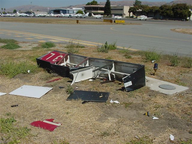
Here's how the NTSB reported the incident:
On August 30, 2005, at 1135 Pacific daylight time, a Bellanca
7ECA airplane, N53893, was substantially damaged when it impacted a runway sign
during an aborted landing on runway 31R at the Reid-Hillview Airport, San Jose,
California. The pilot then diverted and terminated the flight at San Jose
International Airport, San Jose, California. The private pilot, the sole
occupant, was not injured.
According to a written statement provided by the pilot, he was cleared to land
on runway 31R with the wind reported as variable at 5 knots. The pilot conducted
the approach at an idle power setting with some slip that he described as
stable. The airplane touched down near the intersection of taxiway B when he
experienced a "sudden and strong side drift to the right." The pilot
applied full power to abort the landing and was correcting back to the runway
centerline when the airplane
 fuselage contacted a runway sign near taxiway D.
During climb out, the pilot noted that he had limited control with the elevator
and ailerons. He was able to maintain controlled flight, but was limited in
pitch and roll control. Due to his necessity to maintain full left aileron and
nearly full forward elevator control to maintain straight-and-level flight, the
pilot elected to divert to San Jose International Airport to utilize the larger
runway for landing.
The pilot conducted a fly-by of the San Jose International Airport and
determined he had sufficient control to land on the runway. The flight
terminated uneventfully on runway 30R.
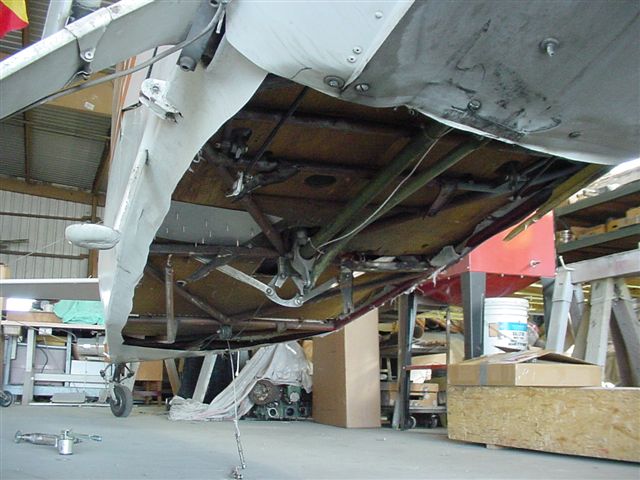
According to the Federal Aviation Administration inspector who responded to the
San Jose International Airport, the airplane sustained impact damage to the
lower fuselage, which broke the aileron pushrod, damaged the skin, and fractured
a structural cross member. The pilot reported no anomalies with the airplane or
engine prior to impacting the runway sign.
The pilot reported accumulating a total of 1,100 hours of flight time, of which
60 hours were accumulated in the same make and model as the accident airplane.
Lessons Learned?
One lesson for sure is to make sure that you're covered by
insurance. If you rent planes, know how big a deductible you may be
expected to pay and consider having renter's insurance. I heard the owner
of the flight school involved say that the $6000 sign cost is covered by
insurance. That helps.
Another principle to consider is that you should always go-around if a landing is not working out. The best advise I've heard on the subject is that if you start to think "maybe I should go around," that's the moment to initiate your go-around. In this case, I heard that the aircraft crossed over from the runway onto the parallel taxiway before a go-around was initiated and the sign was hit during the subsequent takeoff. Perhaps the incident could have been avoided by going around at the first hint that the airplane was leaving the runway.
Finally, you always need to consider whether you'd be better off hitting something at low speed on the ground versus taking off again and making things even worse. That certainly applies to twin engine aircraft, where problems can go from bad to worse in a hurry. In this case, hitting the sign damaged the aircraft controls rendering it almost unflyable. Had the damage been worse, the plane might have crashed.
VFR into IMC
Accidents
Experience does
make a difference
In last month's issue, we quoted University
of Illinois research that analyzes 409 VFR-into-IMC accidents from 1990 to 1997
and tests possible hypotheses on why these accidents occur. It's one of
the few studies that have been done on this topic, and one of the things it
pointed out was that the median number of hours of flying experience for pilots with VFR into IMC
accidents was 580 hours vs. 900 hours for all GA accidents (statistically
significant to the 99% level).
I went back to the study that I did last year on fatal accidents in the S.F. Bay area for the last 10 years to see if the results are similar. Sure enough, they are. For the S.F. Bay Area the median number of hours of pilot experience for all fatal accidents was 975 hours. However, for pilots who have VFR into IMC accidents, the median number of hours of experience was 710 hours.
Oddly, experience doesn't help when it comes to night accidents. For the S.F. Bay area for the last 10 years, the median number of hours of experience for pilots in fatal night accidents was 1300 hours. When you exclude four Part 135 accidents, the median dropped to 1100 hours, still above the median number of hours of experience for all types of fatal accidents.
I recently exchanged email with Paul Craig, author of The Killing Zone. The primary premise of that book is that accidents happen to pilots with relatively low experience. In one of his emails he asked "What if we could train in such a way that we produce pilots that exhibit the traits of more experienced pilots even though they have low time?" That's certainly the focus of the FITS (FAA Industry Training Standards) program, which uses scenario based training and is used heavily in glass cockpit training these days. One way to gain the traits of more experienced pilots is to learn specific tools for determining inflight visibility and cloud separation, which is discussed in the article below.
Estimating
Your InFlight Visibility and Distance From Clouds
It's easy to
remember you need 3 mile visibility; it's harder to know if you have it.
I just finished reviewing for the FAA's
G.A. and Commercial Division in Washington a draft of their General
Aviation Pilot's Guide, which focuses on preflight planning, weather
self-briefings, and weather decision making. It should be done and available on the web by the end of
November, and it is great! Weather is probably the topic that pilots
most consistently have a hard time wrapping their mind around, but since weather
accidents have a particularly high fatal accident rate, it's an incredibly
important topic.
 In a section on In-Flight Decision Making, they talk
about something that we
mentioned recently, which is that "pilots involved in VFR-into-IMC
accidents often venture into reduced visibility conditions because they lack
experience in real-time weather." Later, in a section on Evaluating
and Updating Inflight Conditions, it talks about how our senses are not good
at detecting gradual change, such as what you might encounter in slowly
deteriorating weather conditions. This is an area, where I made a
suggestion that I hope makes it into the final version.
In a section on In-Flight Decision Making, they talk
about something that we
mentioned recently, which is that "pilots involved in VFR-into-IMC
accidents often venture into reduced visibility conditions because they lack
experience in real-time weather." Later, in a section on Evaluating
and Updating Inflight Conditions, it talks about how our senses are not good
at detecting gradual change, such as what you might encounter in slowly
deteriorating weather conditions. This is an area, where I made a
suggestion that I hope makes it into the final version.
Most pilots learn to quote from rote memory that below 10,000 feet, you need to be at least 500 feet below, 1000 feet above or 2000 feet horizontally away from a cloud. Knowing how to do this is incredibly important, since VFR-into-IMC accidents are fatal about 90% of the time. Great. But, when was the last time you read anything that told you HOW to determine your distance from a cloud (short of flying over next to the cloud, which would be illegal and unsafe). The brochure gave one method for doing this, which was:
"There are a number of ways to develop skills for estimating your inflight visibility. One is to listen to the ATIS or ASOS/AWOS as you pass near an airport. First try to evaluate the basic weather conditions based on what you see. Then listen to the ATIS or ASOS/AWOS and compare the official report to your own evaluation of conditions, as well as with any previous reports you have seen from this location."
I suggested that the following methods also be added to the brochure, which I pretty much made up--I don't recall reading these anywhere before. Hopefully these will become general practice in aviation and reduce the number of VFR into IMC accidents.
Also, you can use the length of a runway you're passing in flight to estimate distances. If you pass an airport with a runway that’s 5,300 feet long, that’s about a mile. Look to see how far ahead you can see, and estimate the number of runways that it would take to cover that distance. You’ll need to account for the actual length of the runway you’re passing, so for example a 2,600 foot runway would be about a half mile and so on. In the case of a 2,600 foot runway, if you cannot see six runway lengths ahead, visibility is less than 3 miles.
Knowing your aircraft’s groundspeed, you can also estimate distance. Look ahead to the farthest point you can see and then time how long it takes you to reach that point. If, for example, your ground speed is 105 knots, that’s about 120 mph and you’ll cover about 2 miles per minute. If you reach the point in less than 90 seconds, the inflight visibility is less than 3 miles! A simple variation of this is using GPS or DME while flying directly to or from a waypoint or VOR. Just look at the beginning and ending mileage on the GPS or DME to see how far you've flown to reach the farthest point you can see.
If you want to know how far away you’ll be passing laterally from a cloud, start timing when the cloud is ahead of you and at about a 45° angle (halfway between your 10 and 11 o’clock or between your 1 and 2 o’clock positions). Stop timing when the cloud is off your wingtip. The distance you’ve traveled forward will now be equal to the distance between you and the cloud. So, if you were traveling at about 120 mph, it will take you about 11 seconds to travel 2000 feet. If the cloud took less than 11 seconds to arrive off your wingtip, you’re now less than 2000 feet horizontally from that cloud.
The same technique can be used to estimate whether you're more than 500 feet below the clouds. Look ahead to a point in the clouds that's ahead and at a 45° angle above you and start timing. Stop timing when that point in the clouds is directly overhead. If it takes less than about 3 seconds for the clouds to get overhead, you're less than 500 feet below the clouds.
These techniques will help you establish a continuous weather assessment habit. They will also help you calibrate your perceptions and learn when to trust what you see.
Stupid
Pilot Tricks
One Pilot: Two
incidents in two days

He's back! Fortunately, we haven't had to pull the bozo picture out for a few issues now, but once again, he's climbed into the cockpit with his big floppy shoes and large red nose and pulled off not one but two stunts in the same airplane at the same location on two successive days! Better yet, no one was injured AND there was a video camera rolling to capture the second incident.
Here's the website where you can find the video:
http://us.video.netscape.com/video.index.adp?mode=2&pmmsid=1421230&guideContext=65.491
If you don't find it there, go to http://us.video.netscape.com
and search on search on "Fortunate Pilot."
Here's the story. According to the narrator on the video, the pilot, who's name is mentioned on the video, was en route from Baton Rouge to South Carolina on October 26, when he landed a on city street near Baton Rouge after running out gas. Hmmm. Most fuel mismanagement accidents are pilot error. If you're going to be anal about anything during your preflight planning and enroute, be anal about fuel! Even so, 12% of accidents each year are fuel related.
According to the video, the aircraft was "too big to haul to the airport," so the pilot "had no choice except to takeoff from the street." Are you seeing where this is leading? First, I'm sure the airplane could have been moved to the airport, though it might not have been easy or inexpensive. You can always take the wings off.
Second, city streets generally make poor runways. Besides the potholes and curious bystanders with CAMCORDERS, there are the obstacles that you cannot easily move such as wires, trees, traffic lights and other items not normally found next to runways. Also, there are the many obstacles that could be easily moved--like an EMERGENCY VEHICLE parked on the side of the road--if you bothered to take the few extra minutes it would take to move it.
So next time you decide to exercise bad judgment, just make sure there are no camcorders nearby!
UPDATE: One of our readers, who knows the pilot,
contacted us with the following information, correcting the story information
above:
The pilot was en route FROM South Carolina TO Eunice, LA when he ran out of fuel
(said he miscalculated the headwinds) over Baker, La. His wife was with him
during the emergency landing, but had returned home Wednesday. The pilot was
alone
during the takeoff accident on Thursday.
This video (7 megs) explains that he did try to have the plane trucked to the
airport, but he was concerned the truck was too small and the airplane would get
damaged. Ironically, it shows the now damaged airplane being towed away on
the back of the same truck.
http://www.wafb.com/global/video/WorldNowASX.asp?playerType=native&ClipID1=565126&h1=Pilot
This is the crash only (1 meg):
http://www.wafb.com/global/video/WorldNowASX.asp?playerType=native&ClipID1=564694&h1=Plane
News links:
http://www.wafb.com/Global/story.asp?S=4038264
http://www.chron.com/cs/CDA/ssistory.mpl/bizarre/3421136

We
Test-drive WingX software for the Pocket PC
Lots of information
available at your fingertips
The fine folks at Hilton Software sent me a copy of their WingX
software to review, and I've had a great time using it and 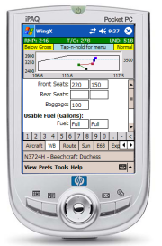 learning more about
it. I just hope that Cirrus and Cessna will take the hint and send me
copies of their products to test and use for awhile.
learning more about
it. I just hope that Cirrus and Cessna will take the hint and send me
copies of their products to test and use for awhile.
All kidding aside, I've known of WingX for some time and had a general idea of its capabilities. Now, having used it, I can tell you that it does a lot more than I imagined and it's indeed a handy product to have as a pilot or CFI. Also, it looks like it's evolving rapidly, and will sport even more features in the near future. I'm particularly excited about some of the weather features they're adding, which are available as beta test software and will be released soon; more on that later.
The product began as a weight and balance application and evolved from there to include half a dozen other major functions. I'm not surprised it started here. Years ago, I created, for my now ancient HP LX200 palmtop, spreadsheets for which I could enter weight and balance information and graph the results for all the airplanes I flew. I discovered then that you're far more likely to run W&B calculations before a flight IF you have a weight & balance application in your pocket. There's something compelling about being able to do it in 60 seconds, versus using the charts in the POH and doing it manually. WingX of course takes this function far further; they've included the basic data for over 400 airplanes.
But let's step back for a moment to outline the major features. Currently, they are two versions, the XL Edition and Pro Edition. The XL Edition includes most features, while the Pro Edition contains several additional functions. To run it, you'll need one of the many Pocket PC's available. In my case, I'm running it on an HP iPAQ that I won while working for HP a few years ago. The basic features are:
Weight & Balance
Route Planning
Airport Facility Directory information
E6B Calculator
FARs, AIM, Pilot/Controller Glossary, METAR codes
The Pro Edition also includes:
Expiration Dates (for pilot currency and aircraft inspections)
Sunrise & Sunset times
Dynamic Flight Navigator that simulates your position in flight
I wish I could tell you my favorite feature, but I can't, since so many of them are useful. Let's start with Route Planning. There are many free tools that you can run on your desktop for route planning. For example, AOPA members can download one from www.aopa.org. However, flying is dynamic and things change. While it's great to print out your planned flight, it's even better to be able to bring along a tool that allows you to update that plan or play "what if" while you're in flight. What if the winds change or your destination is "socked in" and you need to go elsewhere. It's real handy to be able to enter those change in flight and instantly see the results.
To use the Route function, I didn't even have to look in the manual. I just started entering airport identifiers, intersections and VOR's. WingX then pulled data about each from its internal data base and immediately displayed the distance and magnetic heading for each leg. Add your true airspeed and winds aloft, and it then displays estimated time en route, wind correction angles and other information. For flight instructors, this is an easy and accurate way to determine whether a planned flight meets the 50 nm cross-country criteria. It's also an easy way to verify whether a student's flight plan is correct. Route planning was the other capability I had added to my old LX200 via a shareware program, and I'm happy to have it available in my pocket again!
And
there's more
OK, so you've figured out that W&B and route planning were on my
old "must have" list. Many of the other features now help me
with things that I used to do in other ways, but with WingX, the data is now at
my fingertips and I don't need to haul around as many documents.
Take for example sunrise and sunset data. As a flight instructor, I've often asked the tower what the local sunset time was, and they are always helpful in giving it to me. Ask them about "civil twilight," however, and you're out of luck. But, it's important to know if you're to log night time accurately. With WingX, you just click on the "Sun" tab and it shows you sunrise, sunset and the beginning and end of civil twilight for the destination airport that you entered for your route. Or, you can enter any airport identifier and it will calculate the times for you. Simple and effective.
The documents section is also great. Just the other day, I was sitting with a client discussing the equipment requirements of FAR 91.205. That's where the FAA lists the basic equipment that must be operating in order to fly your plane legally. While I could remember all of the requirements for Day and Night VFR, I wasn't sure if I was remembering everything required for IFR. With a couple pokes of the stylus, we had that regulation at our fingertips.
You may not be a flight instructor and need to refer to the regs often but, how many times have you read a METAR report and wondered what some of the more cryptic codes in the Remarks section really meant? In the WingX document section, there's a list of National Weather Service contractions and that will help you crack the code. With it, you'll never be in a quandary when you read a METAR remark about BN at the BCH (Blowing Sand at the Beach) or BS in the BRKSHRS (blowing snow in the Berkshires). The documents section also includes the Pilots/Controller Glossary and a few items from the Airman's Information Manual.
The Airport/Facility Directory is also helpful. Just enter an airport ID and you'll instantly get a list of frequencies and the phone number for the ASOS/AWOS or ATIS for that airport. Additional taps on the Pocket PC give you location, facility and runway information for the airport. This and other databases in WingX can be updated anytime, if you have a wireless Pocket PC, or whenever you synchronize it with an internet connected desktop PC
Other features include an E6B calculator, a section that keeps track of when your pilot currency and aircraft inspections are due and the Dynamic Flight Navigator, which when started, estimates your current position along the route that you have flight planned. The Dynamic Flight Navigator shows your position relative to the 3 nearest VOR's. It doesn't use GPS (or a moving map), so your actual position will be different if the winds vary from the forecast, however, you can re-synchronize your position whenever you pass over a VOR.
Weather
data is coming
WingX currently has a beta version of a weather application posted on
its website, and it's due to be integrated with the main application soon.
Whenever you connect to the internet, it downloads METAR, Winds Aloft and
temperature data for whatever state you select. If your plans change while
you're in the air, you can look up what the conditions were for some alternate
airports.
It can also display weather trends, which was something I was talking about with another client last week as we were discussing whether to send him out for his solo cross-country flights. While it's important to know the current weather, it's probably even more important to know the trend, since it gives you an idea of what might happen over the next few hours. WingX takes the last 6 hours of METAR data and graphs it so you can see the trend for visibility, wind direction, wind speed, ceiling, temperature and pressure.
The Winds Aloft and temperature data are also useful. WingX goes one step further in that it interpolates the temperatures at each altitude and calculates exactly where the freezing level is located, which is a handy feature for IFR pilots.
You've probably already spotted the one short coming related to weather--it's only as current as the last time you updated it through an internet connection. On the other hand, you don't pay an additional fee for a weather subscription, as you do with most products. My guess--and I really don't know--is that eventually WingX will evolve to a point where you'll be able to get weather updates in the cockpit either through a wireless connection or perhaps a cell phone.
You can find more details about this product at www.hiltonsoftware.com. Currently the XL Edition sells for $49.95 and the Pro Edition is $79.95. If you're a student pilot and you already own a Pocket PC, you'll find this is an excellent alternative to buying an electronic E6B calculator. You'll pay about the same and get far more than just an E6B.
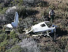 Here's what we know
of the first crash as reported by the NTSB and several newspapers. The personal
cross-country flight originated at Gillespie Field, San Diego/El Cajon,
California, on Monday, October 17 at 1011, with a destination of Scottsdale,
Arizona. Three people were on board and were returning to Scottsdale after attending the
50th anniversary of the Miramar Air Show at the United States Marine Corps Air
Station in San Diego.
Here's what we know
of the first crash as reported by the NTSB and several newspapers. The personal
cross-country flight originated at Gillespie Field, San Diego/El Cajon,
California, on Monday, October 17 at 1011, with a destination of Scottsdale,
Arizona. Three people were on board and were returning to Scottsdale after attending the
50th anniversary of the Miramar Air Show at the United States Marine Corps Air
Station in San Diego.
The plane was owned an operated by the owner of the Columbia dealership located in Arizona that was responsible for their sales in the southwest portion of the United States. Although the owner was a private pilot who didn't have an instrument rating, he was accompanied by his demonstration pilot. This 33 year old man held an Airline Transport (ATP) certificate and single and multiengine flight instructor ratings, arguably among the highest level of certificates one could attain, short of type ratings for heavy aircraft.
The Civil Air Patrol found the wreckage about 10 a.m. Wednesday on a mountain ridge in Anza-Borrego Desert State Park, 50 miles east of the San Diego Airport. One newspaper reported "Officials say it was rainy and cloudy at the time," while the preliminary NTSB report stated that conditions were VMC.
What the heck
happened?
Unfortunately, we cannot get into the mind of the pilots; otherwise
we'd know more about exactly what happened. Instead were left looking at
the few discernable facts and guessing. Some of the facts are the METARS
for Gillespie Field that morning, which I've pulled from a database. These
were the prior three observations, the last one taken 24 minutes before they
departed.
METAR KSEE 171547Z 00000KT 7SM OVC014 17/13 A3001 RMK BINOVC E
SPECI KSEE 171635Z 00000KT 9SM SCT015 22/13 A3001
METAR KSEE 171647Z 00000KT 9SM FEW015 25/12 A3002 RMK HZ ALQDS
The first observation, taken 1 hour and 24 minutes before takeoff, showed 7 miles visibility and an overcast at 1400 feet--pretty typical for any morning at an airport located next to the Pacific Ocean. Later, a special report showed conditions improving to 9 miles visibility with scattered clouds at 1500 feet. The final report shows only a few clouds at 1500 feet, but noted in the remarks section that there was "haze in all quadrants."
The next fact we know is that there was no flight plan, so it was a VFR flight. Here's where the first question come up. Why weren't they on an instrument flight plan? It was a hazy day, and there were high mountains immediately to the east along their route of flight. It's not unusual to have mountain obscuration in the mornings.
Often pilots don't file IFR if they're not current (about half of instrument pilots are not current) or if they want to save a few minutes, since IFR flights always seem to add a few minutes to the total flight time. Oddly, many instrument pilots still have VFR-into-IMC accidents. Presumably this occurs since they feel that they can either get a pop-IFR flight plan if they really need it or that since they have a rating, they are somehow inherently more talented in flying in low visibility. The accident record, however, proves many of them wrong.

Glass cockpit of Columbia 400 on display at Palo Alto Airport Day
Here's one possible scenario. Two pilots departed in VFR conditions, confident in their ability to complete their flight as planned. After all, they were flying one of the world's most modern single engine aircraft, and they may have been among the most qualified people in the world to fly that airplane. These factors may have lead to extraordinary self confidence--not totally unjustified--in their ability to complete this flight as planned.
Perhaps they encountered an overcast--remember the newspaper report that "it was rainy and cloudy at the time." Certainly, the terrain was rising as they flew east. Gillespie Field is near sea level, and the crash site was in mountains that rise to over 6,000 feet.
If there are any lessons to be learned they might be:
1) Don't count on the best technology and your many ratings to save you from all
situations
2) DO have alternate plans and follow them at the first signs of things not
working out
3) DO file IFR if you have the option of doing so when the weather is less than
perfect.
Second
Columbia 400 Crashes
Bad week for the
Columbia
Hard to believe. I barely finished writing about the first
Columbia 400 accident, when I learned of the second one. Harder yet to believe
when you realize that Columbia (formerly Lancair) only builds about 10 of these
planes a month and there are fewer than 150 in existence. Here's what the NTSB
said about the accident in their report.
On October 22, 2005, at 1927 mountain daylight time, a
Lancair LC-40-550FG, N101HK, operated by Kittyhawk Partners LLC., and piloted by
a private pilot, was destroyed when it impacted terrain 10 miles east of
Steamboat Springs, Colorado. Night visual meteorological conditions prevailed at
the time of the accident. The personal flight was being conducted under the
provisions of Title 14 CFR Part 91. An instrument flight rules flight plan had
been filed and activated; however, it was cancelled at 1920. The private pilot
and his passenger were fatally injured. The cross-country flight departed
Burlington, Iowa, and was en route to Bob Adams Field, Steamboat Springs,
Colorado.
According to a group of hunters in the area, the airplane flew over their camp
approximately 300 feet above ground level. The airplane was extremely low and
the lights of the airplane illuminated the ground. One hunter reported the
engine was sputtering and backfiring. Shortly thereafter, the hunters heard
three loud pops.
The airplane was located by the Routt County Search and Rescue Team,
approximately 1130, on October 23, 2005. The airplane was located in a densely
wooded area on the north face of Walton Peak, at an approximate elevation of
10,500 feet mean sea level.
Rumor
Mill.....
Do your Flight Review
(BFR) online?
Every two years, a pilot needs a Flight Review, formerly called a biannual
flight review. That entails spending a minimum of one hour of ground
discussion and one hour of flight instruction with an instructor.
Alternatively, you can get a new rating or participate in the Wings
program. For the Wings program, you need to attend a FAA safety seminar
and then get 3 hours of dual instruction.
Over the last year or two, several online training programs have appeared that qualify for the seminar portion of the Wings program. So, instead of attending a seminar, you can go to www.aopa.org/asf, take a free course on line, print your certificate and then get the 3 hours of flight instruction to complete your Wings. Now, it appears that you'll soon be able to do the same thing for the one hour of ground instruction required for a Flight Review. Stay tuned and we'll let you know more when this comes to fruition.
Local
Events
November 1, 2005 7PM The Last Five
Miles, Safety Seminar, NASA Ames, Mountain View, CA Eagle
room
November 12, 2005 10AM G1000 Glass Cockpit Seminar, West Valley Flying Club, Palo Alto Airport
November 16, 2005 7PM Fly the Bay Tour Seminar, California Airways Flight School, Hayward Airport
Pilot Safety News
© 2005 by Max
Trescott
Master CFI & FAA Aviation Safety Counselor
Please contact me with your feedback or if I can be of service to you.
www.sjflight.com
(650)-224-7124 Subscribe or email Feedback on
Newsletter